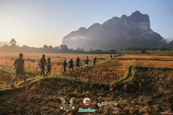
The elevation profile is a far cry from the actual terrain itself. After an almost 4 hour minivan ride, we arrived at Vang Vieng town, and walked to INTHIRA hotel for our race pack before we drop off our luggage at Simon Riverside Hotel. The view of Nam Song river is simply breathtaking.
I came to Vang Vieng for a taste of adventure. It turned out more than just that, it packs more than a punch! I signed up for the 18km trail run, and Gertjan, my partner has signed up for the 52km trail run.
My memory of this run experience really revolves around the 52km rather than the 18km one. Gertjan predicted that he would complete the race before dawn. But reality was, he only returned after midnight. That minutes of waiting between 6pm until his return was most excruciating, as i cannot possibly imagine the risks he faced in the dark through that terrain. I didn’t think much of the terrain initially, until at around 2215, two participants came in, and relayed the danger navigating through that terrain, and that the risks just wasn’t worth it (on hindsight). I felt shiver down my spine. I froze for a moment. I called him, but to no avail. 30 minutes later, i received his text, and said he may finish by midnight. A moment of relieved. I swear at that time that i will never sign up for a race where we would run two separate distances, at least we could have each other. Suppresses the worry.
We only arrived at the hotel about 0200 on 4 November. My race will start in 4 hours. I contemplated not starting my race after listening to the 52km participants’ stories, and with the lack of sleep, i wasn’t sure that it is a good idea at all. Then again, i did come all the way to Vang Vieng for a different experience. Because i wanted to confirm my imagination of the risks, and feel what the chatter was about, or at least some parts of it, i decided that i needed to go.
It turns out, to be more of a rock climbing and obstacle race. Some trial and error on how to get to the next level because of the rock formation. I thought as much before the race, but it was wilder than my imagination. The route was clearly marked, but the mistake i made repeatedly was to follow the person in front of me, rather than the marking itself. I got lost a few times because of the false lead. But the worse off-route mistake made was one which brought me (and us) toward a steep rock of almost 100 – 110 degree angled, and for a moment there, i thought i was going to fall off the cliff. This route would have brought us toward the tip of the waterfall. I cling on the slab of rock, cried for help, and refused to move. I needed to step downward, but i cannot see nor reach the flat edge of the rock which would allow me to stay vertical, but then a veteran agile Thai man called out to me, and said “you can step on this edge…come on”, and i guess when in doubt, trust is all i have to give. And there were at least 3 more runners behind me. Not very nice to keep everyone waiting… bahhh… and i jump (oh so lightly). Safe and on track.
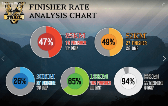
On my watch, it took me approximately 3.19 hours to complete the under-distance (13.7km), 907m elevation, obstacle-filled, steeply angled mountain. On Strava, my moving time was approximately 2.39 hours, which means quite some time was spent thinking about how to get to the top!
One thing i have left out though, the view was stunning. But is it worth the risks?


Source:
https://www.facebook.com/VangViengTrail/
